- Home
- Community
- Business
-
Tourism
- Towns
- Accommodation
- Attractions
- Activities
- Gallery
- Maps
- Outings
- Pet-friendly accommodation
- S.A. Distance Chart
- Tide Chart
- Tourism Offices
- About Us
- Products
- User Menu
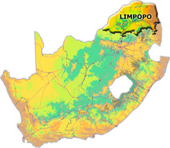 Limpopo is South Africa’s northernmost province. It shares borders with North West to the southwest, Gauteng to the south, and Mpumalanga to the southeast, as well as international borders with Botswana to the northwest, Zimbabwe to the north and Mozambique to the east. The province gets its name from the mighty Limpopo River, which flows along its northern border. With a total area of 123 910 square kilometres, Limpopo is slightly larger than the US state of Pennsylvania. Its capital city is Polokwane.
Limpopo is in the savanna biome, an area of mixed grassland and trees generally known as bushveld. As a summer-rainfall region, the northern and eastern areas are subtropical with hot and humid summers and mist in the mountains. Winter is mild and mostly frost-free.
Rich in natural beauty, culture and wildlife, Limpopo has a thriving tourism industry. In addition to the Kruger National Park to the east, there are 54 provincial reserves and several luxury private game reserves.
Economy
Limpopo recorded an economic growth rate of 4.4% during 2007, and 4.6% in 2006. Its economy is valued at R138.2-billion, and like Mpumalanga it contributes 6.9% to national GDP.
The province’s largest industries are mining and quarrying (24.4% of the 2007 GDP), finance, real estate and business services (16.7%) and general government services (16.3%). In 2007 construction had the lowest contribution (1.7%) to Limpopo’s GDP at market prices.
For Limpopo Accommodation Listings click > here<